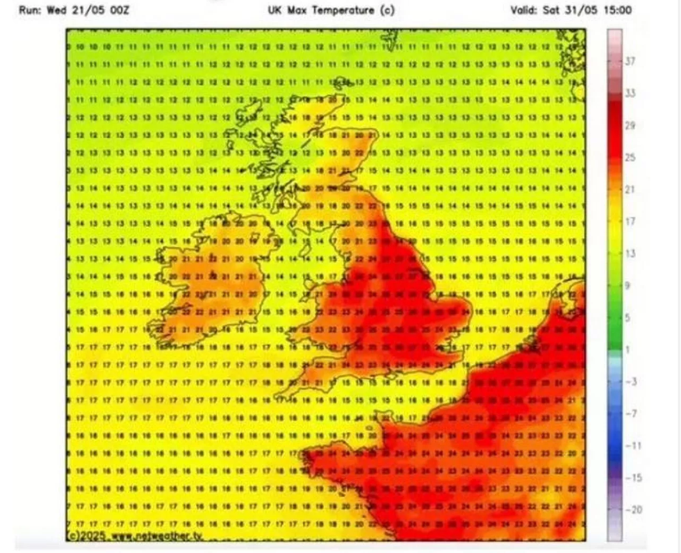
Temperatures across the UK are forecast to surge in the coming days, with a mini-heatwave expected to bring highs of up to 27°C. Weather maps have turned red as forecasters predict at least 23°C across 45 counties in England and Wales, with the southeast expected to feel the peak of the heat.
The rise in temperatures comes as the Environment Agency reports the driest start to spring in nearly 70 years. The lack of rainfall has led to challenges for wildlife and farmers alike, with parched fields and water shortages in country parks becoming more evident.
The latest forecasts show that the heat will build towards the end of May, reaching its peak on 31 May. Southeastern areas, including London, Kent, and Surrey, are expected to record the highest temperatures of 27°C. The warm spell is also set to stretch northwards through counties such as Nottinghamshire and into parts of West and North Yorkshire, including cities like York and Harrogate, where the mercury is expected to rise to at least 23°C.
While a brief drop in temperatures is anticipated on 1 June, forecasters believe the heat will persist in the southeast, with London still likely to see temperatures of 27°C during the daytime peak. Commuters and residents in the capital are advised to prepare for the hot weather.
The Met Office has announced that weather forecasting in the UK is set to become more advanced, with the launch of a £1.2 billion supercomputer. Capable of performing quadrillions of calculations per second, the new system is expected to significantly improve the accuracy of long-range forecasts.
Charles Ewen, Chief Information Officer at the Met Office, said: “One big thing this new computer will allow us to do in the near future is to be able to produce 14-day forecasts with a similar kind of accuracy than we can today for seven, eight, nine days.”

Looking ahead, the Met Office’s long-range forecast covering the period from 25 May to 3 June anticipates a shift to more humid and unsettled conditions across much of the country. While some areas are expected to enjoy dry and bright spells, widespread showers and longer periods of rain are also forecast.
The west of the UK, particularly the northwest, is likely to experience heavier and more frequent showers, along with stronger winds. In contrast, the east, and especially the southeast, is forecast to see more dry weather. The Bank Holiday weekend (26–27 May) is likely to bring a mix of sunshine and showers across the country.
The unsettled conditions are expected to continue into early June, with further frontal systems bringing rain across the UK. However, these will be interspersed with drier intervals. Temperatures during this period are predicted to be around the seasonal average, occasionally climbing slightly above average, although the presence of strong winds may make conditions feel cooler.
Here is a list of the 45 counties expected to see temperatures of 23°C or higher:
England:
Kent, East Sussex, West Sussex, Hampshire, Dorset, Somerset, Wiltshire, Berkshire, Surrey, Greater London, Essex, Hertfordshire, Buckinghamshire, Oxfordshire, Gloucestershire, Herefordshire, Shropshire, Cheshire, Staffordshire, Worcestershire, Warwickshire, Northamptonshire, Bedfordshire, Cambridgeshire, Suffolk, Norfolk, Leicestershire, Derbyshire, Nottinghamshire, Merseyside, Greater Manchester, South Yorkshire, West Yorkshire, Lincolnshire, North Lincolnshire, North East Lincolnshire, Kingston upon Hull, East Riding of Yorkshire, North Yorkshire, Lancashire
Wales:
Flintshire, Denbighshire, Powys, Wrexham, Monmouthshire
With high temperatures and dry conditions expected to persist in many areas, residents are advised to stay hydrated, avoid unnecessary travel during peak heat, and monitor local weather updates for any changes.


